 The 360 Guy
The Realsee Galois P4 is the most advanced virtual tour camera I have tested. It is also one of the most expensive.
Unlike a conventional 360 camera, the P4 combines extremely high-resolution panoramic photography with LiDAR scanning. This allows it to create detailed virtual tours, 3D dollhouse models, point clouds, floor plans and accurate digital representations of real-world spaces.
After testing the Realsee P4 in large venues, smaller rooms and spaces with difficult lighting, I came away seriously impressed by both its image quality and how easy it was to use.
However, with a price of more than $7,000, this clearly is not a camera for everyone. Although you can get $300 of using my discount code The360Guy when buying from this link.
In this Realsee P4 review, I will cover:
- What the Realsee P4 can do
- Realsee P4 image quality
- How the LiDAR scanning system works
- How easy it is to create a virtual tour
- The available exports and deliverables
- How it compares with the older Realsee Galois M2
- Whether it is a genuine Matterport Pro3 alternative
- Who should consider buying it
Realsee P4 review: the quick verdict
The Realsee Galois P4 is one of the best all-in-one virtual tour capture systems currently available.
Its biggest strengths are its outstanding panoramic image quality, fast scanning, long-range LiDAR, large amount of internal storage and ability to produce numerous professional deliverables from a single capture project.
The image quality is among the best I have seen from a non-DSLR 360 system. The camera also handles bright windows, difficult exposures and fine architectural details extremely well.
Most importantly, the P4 offers this level of quality without requiring the operator to understand complicated camera settings.
It is expensive, but businesses producing high-end virtual tours, digital twins, construction documentation or architectural surveys may be able to justify the investment.
For someone who only wants attractive 360 photographs, however, the Realsee P4 would be complete overkill.
Realsee Galois P4 specifications
| Specification | Realsee Galois P4 |
|---|---|
| Camera type | Professional LiDAR scanner and virtual tour camera |
| Virtual tour resolution | Up to 24K |
| Panoramic image resolution | Approximately 300 megapixels |
| Image sensor | Single Micro Four Thirds sensor |
| LiDAR type | 905nm LiDAR scanner |
| Maximum LiDAR range | Up to 100 metres in ideal conditions |
| Point capture speed | Up to 125,000 points per second |
| Internal storage | Approximately 512GB |
| Typical scan time | Approximately 16 seconds per scan position |
| Display | Built-in touchscreen |
| HDR | Automatic multi-exposure HDR capture |
| Capture modes | Standard and high-quality modes |
| Main outputs | Virtual tours, dollhouse models, point clouds, floor plans, measurements and panoramic images |
| Approximate price | More than $7,000, depending on package and region |
What is the Realsee Galois P4?
The Realsee Galois P4 is a professional LiDAR-powered 3D scanner and virtual tour camera.
It is designed to capture both photographic and spatial information. Instead of simply taking a 360-degree image, the camera scans the shape and dimensions of its surroundings while photographing the space.
The resulting data can be used to create:
- High-resolution 360 virtual tours
- 3D dollhouse views
- Digital twins
- Point clouds
- Automatic floor plans
- Spatial measurements
- Downloadable panoramic images
- Architectural and construction documentation
This makes the P4 particularly relevant to industries such as real estate, architecture, construction, hospitality, insurance, facilities management and cultural venues.
Realsee P4 design and controls
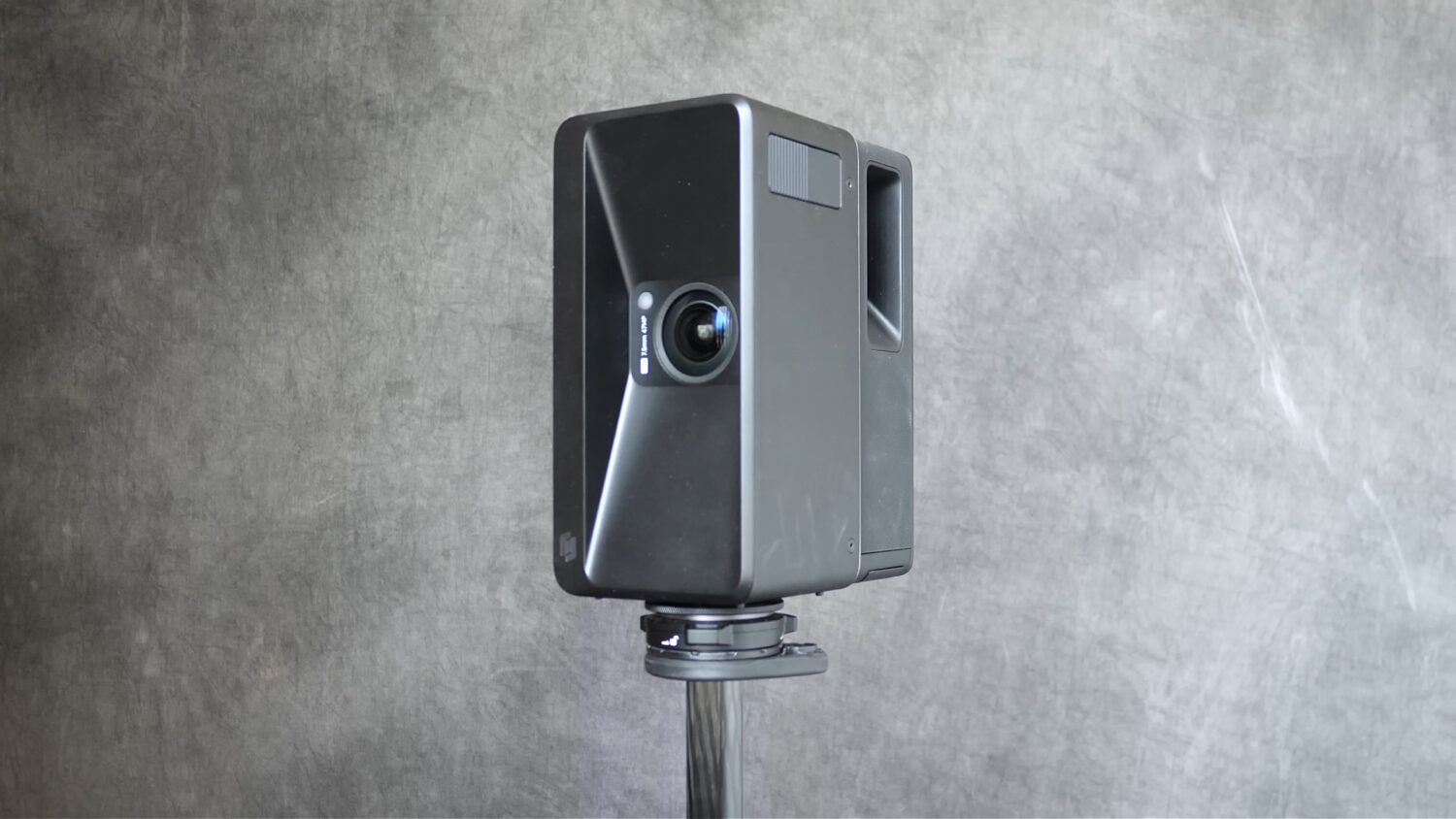
The Realsee P4 is a substantial piece of equipment. It looks and feels more like a professional surveying instrument than a conventional 360 camera.
To use it, you mount the camera on a tripod and position it at different points throughout the space.
During each scan, the camera rotates on its axis, capturing photographs and LiDAR data as it turns. These individual images are then automatically stitched together to create the final panoramic image.
One of the biggest improvements over the older Realsee Galois M2 is the addition of a touchscreen.
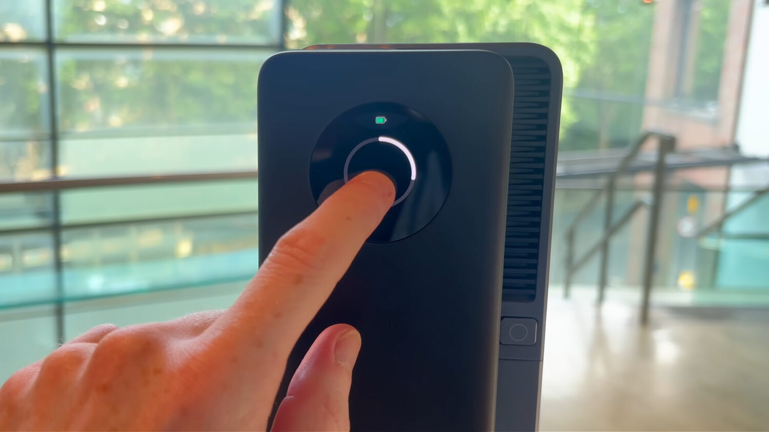
The touchscreen allows you to start a capture directly from the camera without needing to remain connected to a smartphone. Combined with the large amount of internal storage, this makes the P4 feel like a genuinely independent capture system.
You can still connect the camera to the Realsee app, which is useful because it lets you see the 3D model taking shape as you move through the building.
How easy is the Realsee P4 to use?
Despite its size and technical capabilities, the Realsee P4 is surprisingly easy to operate.
The basic capture process is:
- Mount the P4 securely on a tripod.
- Turn on the camera.
- Connect it to the Realsee app.
- Create a new project.
- Position the camera within the space.
- Start the scan.
- Move the camera to the next scan point.
- Repeat until the entire area has been captured.
Individual scan points should generally be positioned within approximately three or four metres of each other. This gives the system enough overlapping visual and spatial information to understand how each scan connects to the next.
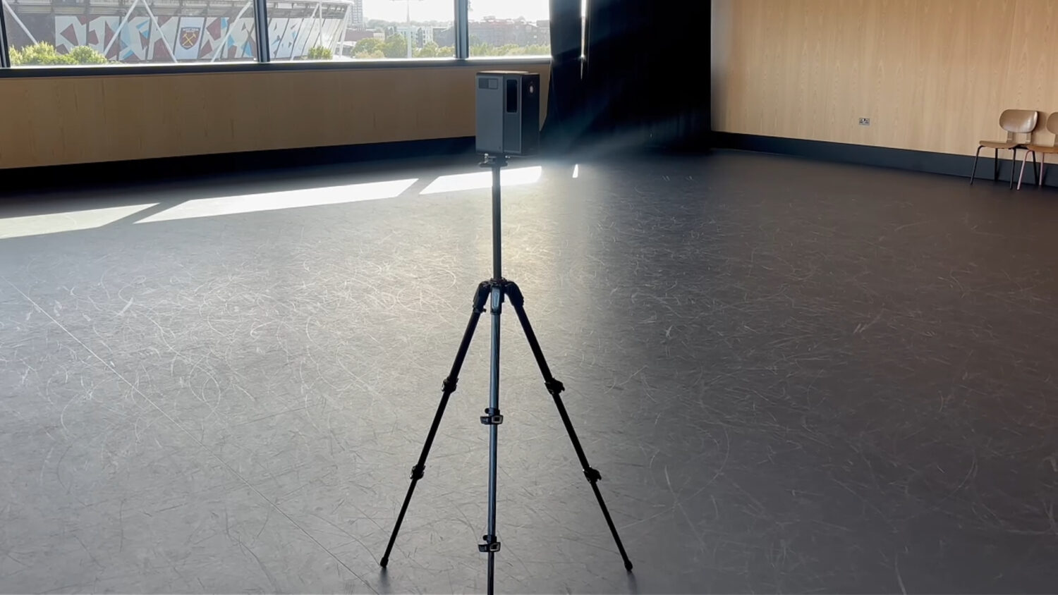
The camera automatically captures multiple exposures and combines them using HDR processing. You do not need to manually select ISO, shutter speed, aperture or white balance.
For most users, the biggest skill will not be operating the camera itself. It will be learning where to position it to ensure complete coverage of the space.
You need to think about doorways, corners, lines of sight and how each scan position connects to the previous one. Fortunately, the mobile app shows the model developing as you work, making it easier to identify missing areas.
Anyone comfortable using a smartphone camera should be able to understand the basic P4 workflow relatively quickly.
Standard mode versus high-quality mode
The Realsee P4 offers different capture options depending on whether you prioritise speed or maximum image quality.
Standard mode captures each scan more quickly, making it useful when covering very large spaces or working under time constraints.The high-quality option takes longer and records more image information.
In my testing, the difference between the two modes was not immediately dramatic. Standard mode still produced excellent results.
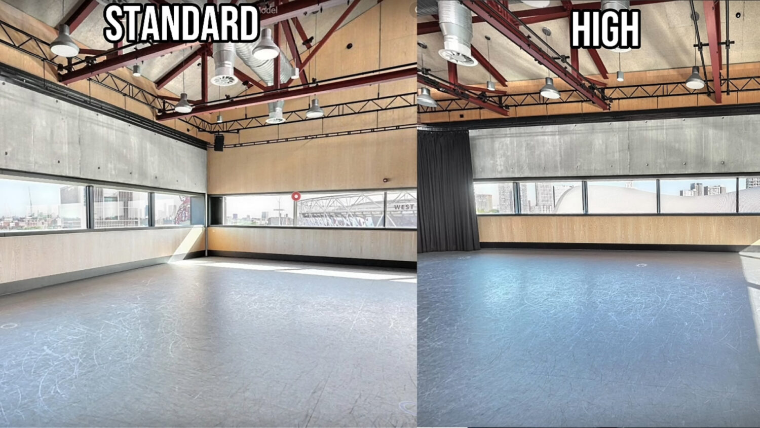
However, the high-quality option may be worthwhile for premium projects, particularly when the client is likely to inspect small details, zoom into the images or display the tour on a large screen.
For everyday property tours, standard mode will probably be sufficient. For architecture, construction, luxury real estate or detailed documentation, I would lean towards the higher-quality setting.
Realsee P4 image quality
Image quality is where the Realsee P4 really stands out.
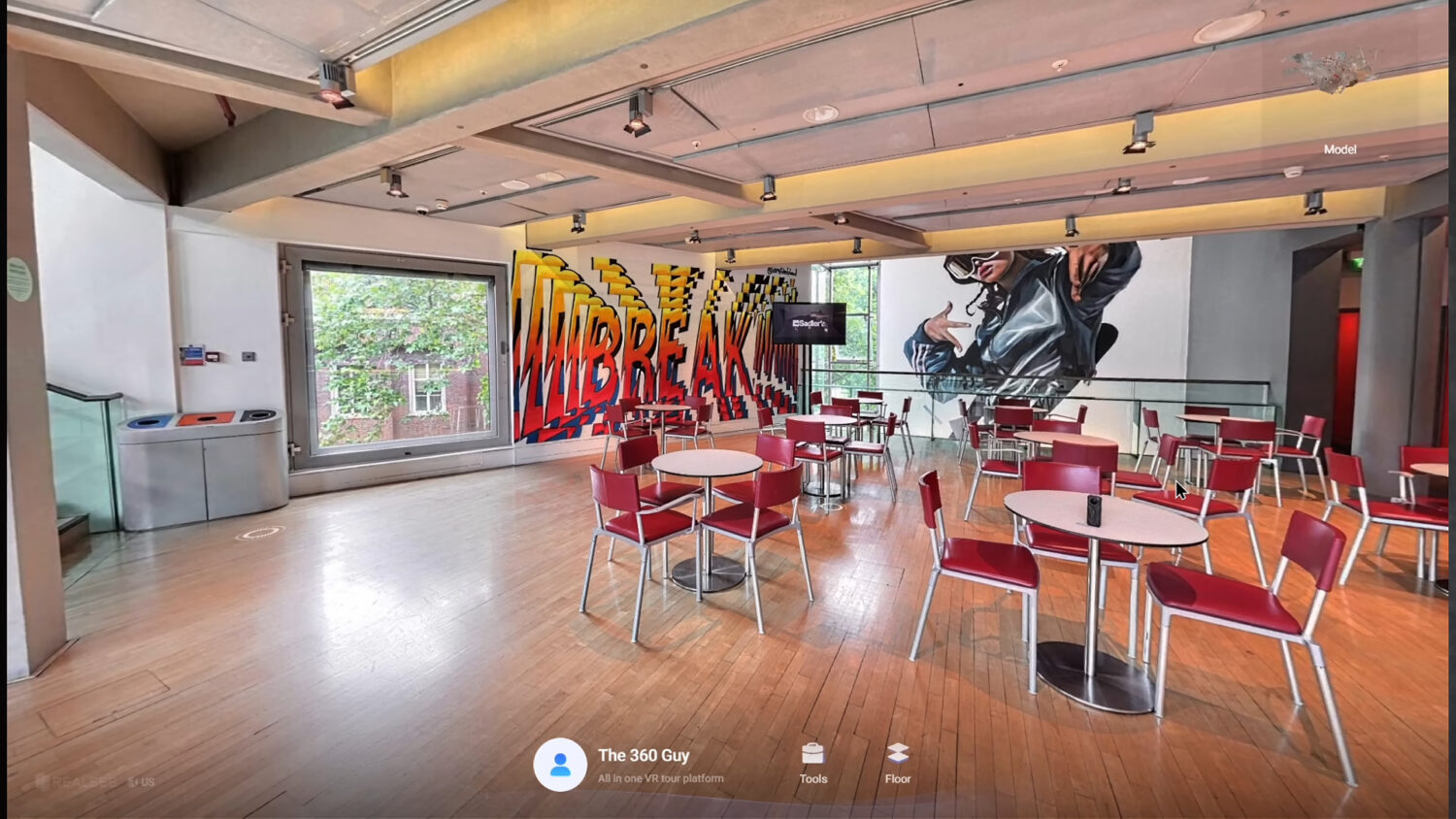
The panoramic images are enormous, reaching approximately 300 megapixels. This gives you far more detail than a typical consumer 360 camera and allows viewers to zoom much further into a scene.
The results look closer to a DSLR-based virtual tour than something captured using a conventional dual-lens 360 camera.
Fine textures, signs, architectural features and objects positioned further away remain clearly visible. This is especially valuable when the tour is being used for more than simply showing the general appearance of a space.
For example, someone viewing a building remotely may need to inspect fixtures, materials, equipment or structural details. The P4 captures enough information to make this genuinely useful.
Realsee describes the system as providing up to eight-times lossless zoom. The term “lossless” should be treated cautiously, because any digital zoom will eventually reveal a reduction in quality.
Nevertheless, the amount of detail retained while zooming is significantly better than most all-in-one 360 cameras I have used.

HDR and window performance
Bright windows are one of the most difficult things for any virtual tour camera to capture.
A camera will often expose the interior correctly but completely overexpose the view through the windows. Alternatively, it may preserve the exterior and leave the room looking dark.
The Realsee P4 performed extremely well in these situations.
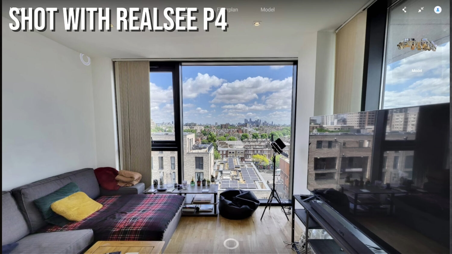
During my tests, I could clearly see details outside bright windows while the interior remained correctly exposed. This was achieved automatically through the camera’s HDR processing, which captures and combines multiple exposures.
This makes the P4 particularly useful for:
- Hotels
- Luxury properties
- Venues
- Restaurants
- Offices
- Retail spaces
- Buildings with large windows
- Properties where exterior views are an important selling point
You do not need to manually bracket exposures or process the images yourself. The camera handles the entire HDR workflow automatically.
Are there any image-quality problems?
The overall image quality is excellent, although it is not completely flawless.
In a small number of my scans, I noticed some chromatic aberration. This appeared as a slight purple fringe in certain dark or high-contrast areas.
Chromatic aberration is fairly common with 360 cameras and wide-angle lenses. In my testing, it only appeared in a very small percentage of the images, so I would not consider it a significant problem.
It may also be possible to correct some of these issues after downloading and editing the panoramic images.
Across approximately 30 to 40 captures, the large majority looked extremely clean.
Realsee P4 LiDAR performance
The P4’s LiDAR system is what transforms it from a high-resolution camera into a complete 3D scanning platform.
LiDAR works by emitting laser pulses and measuring how long those pulses take to return after hitting surrounding surfaces.
Using this information, the P4 can calculate:
- Distance
- Depth
- The shape of objects
- The dimensions of rooms
- The location of walls and surfaces
- The spatial relationship between different scan points
The P4 can capture up to 125,000 points per second and has a claimed range of up to 100 metres in ideal conditions.
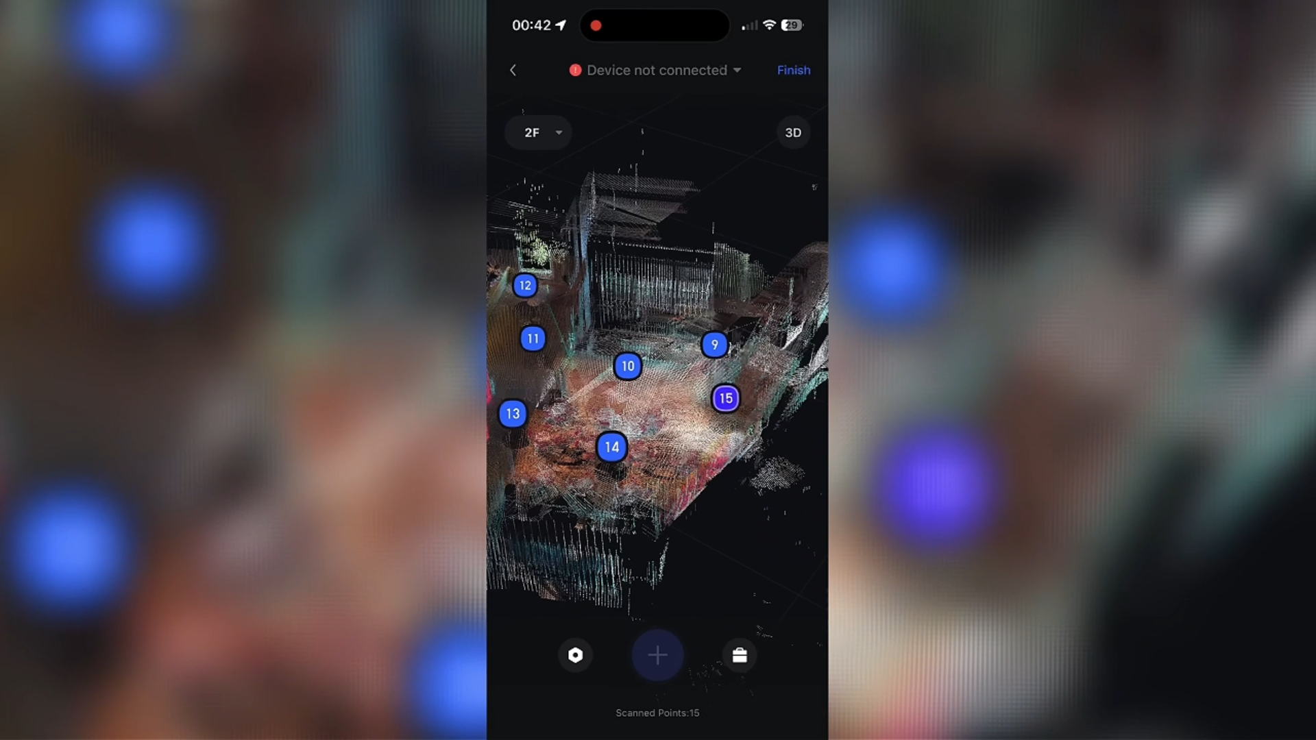
The resulting point data appears quickly within the app as you capture each location. Watching the model form in real time is useful because it confirms that the camera understands where each scan belongs.
This spatial data makes the P4 suitable for much more than property marketing.
It could be used for documenting construction progress, recording the condition of a building, planning renovations, managing facilities or allowing specialists to inspect a location remotely.
What can you create with the Realsee P4?
One of the strongest reasons to consider the P4 is the number of assets that can be created from a single capture session.
High-resolution 360 virtual tours
The most obvious output is a high-resolution virtual tour.
Viewers can move between scan points and inspect the space as though they were physically present.
3D dollhouse models
The photographic and LiDAR data can be combined to create a 3D dollhouse-style overview of the entire property.
This helps viewers understand the relationship between rooms, floors and different sections of the building.
Point clouds
Professional users can obtain point-cloud data representing the physical geometry of the scanned environment.
This may be valuable for architecture, construction, engineering and building documentation.
Automatic floor plans
The system can generate floor plans using the dimensions and layout captured by the LiDAR scanner.
This can save a considerable amount of time compared with manually measuring and drawing each room.
Digital measurements
Because the system has captured spatial data, users can take measurements within the digital model.
This can be useful when planning installations, checking clearances, reviewing dimensions or discussing a space with someone who cannot visit it physically.
Downloadable panoramic images
You can also export individual panoramic images and use them outside the Realsee platform.
This is important because some competing platforms tightly restrict access to the original 360 images.
The downloaded panoramas could potentially be edited, archived or uploaded to another compatible platform.
Some exports and deliverables may require additional credits or charges, so this needs to be considered when pricing client projects.
Realsee P4 versus Realsee Galois M2
The P4 represents a substantial upgrade over the previous Realsee Galois M2.
The most noticeable improvements include:
- Higher-resolution panoramic images
- Better overall image quality
- Faster scanning
- More advanced LiDAR performance
- A built-in touchscreen
- Approximately 512GB of internal storage
- Improved processing hardware
- More independent operation without a smartphone
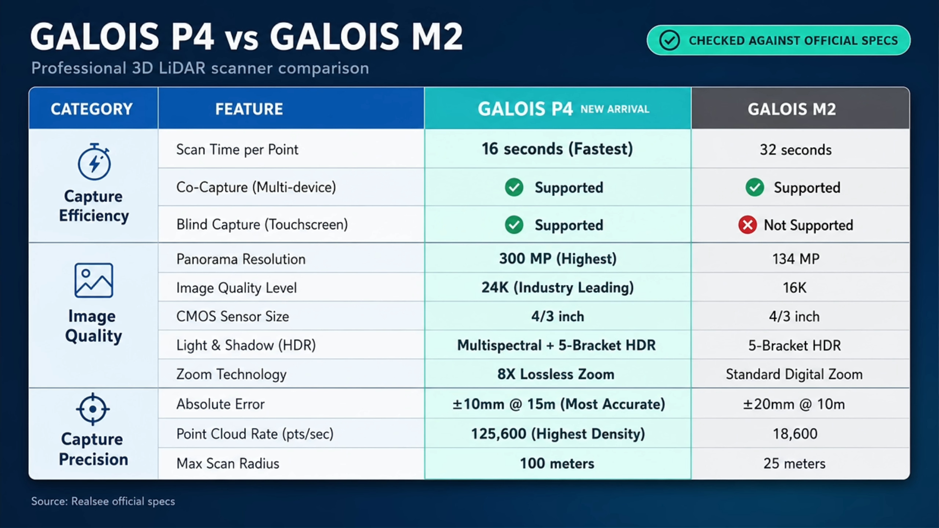
The Galois M2 was already capable of creating professional virtual tours, but the P4 feels like a more complete and premium system.
The touchscreen and internal storage make a particularly big difference to everyday use. You are less dependent on maintaining a constant phone connection and have far more room to store projects directly on the camera.
For businesses already using the M2, the main question is whether the improvement in image quality and efficiency will generate enough additional revenue to justify upgrading.
For new buyers who need the best available Realsee hardware, the P4 is the obvious choice.
Realsee P4 versus Matterport Pro3
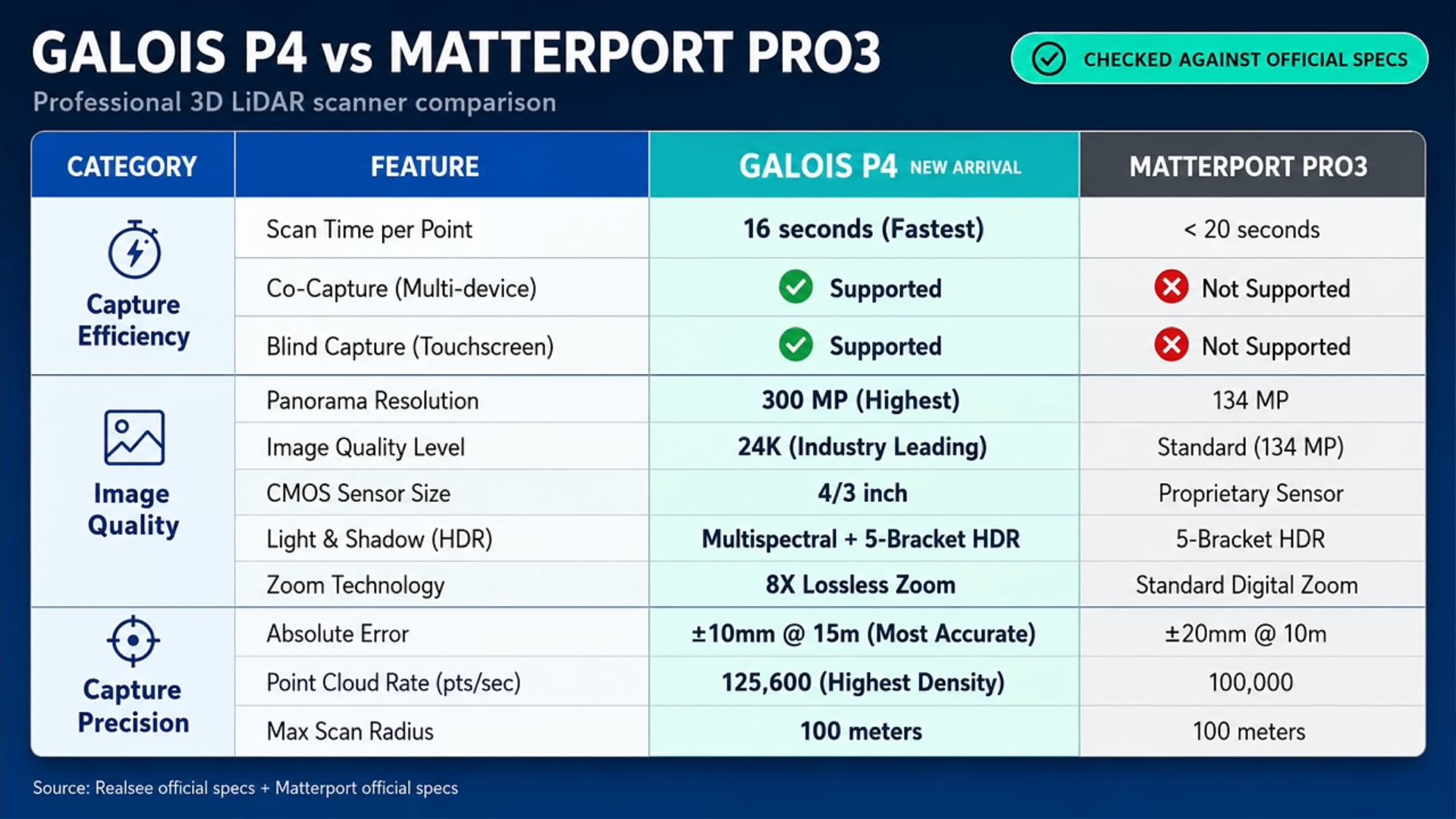
Matterport remains the best-known brand in the professional 3D tour market. The Matterport Pro3 is therefore the most obvious competitor to the Realsee Galois P4. The Pro3 has a lower initial camera price, while the Realsee P4 costs more than $7,000. However, the upfront cost is only part of the comparison.
Hardware specifications
On paper, the Realsee P4 offers some significant advantages, including:
- Higher-resolution panoramic images
- Large internal storage capacity
- Strong LiDAR specifications
- A standalone touchscreen
- Extensive zoomable image detail
The P4’s panoramic image quality is one of its biggest advantages. For projects where presentation and visual detail matter, the difference could be important.
Platform and ongoing costs
Matterport is closely tied to its subscription ecosystem.
Users typically pay a recurring subscription based partly on the number of active spaces they need to host. Certain exports, floor plans and technical deliverables may also involve additional fees.
Realsee uses a credit-based model for hosting and for generating certain outputs.
This means you need to consider both:
- The upfront cost of the camera
- The number of credits required for each project
- Ongoing hosting requirements
- The cost of optional exports and deliverables
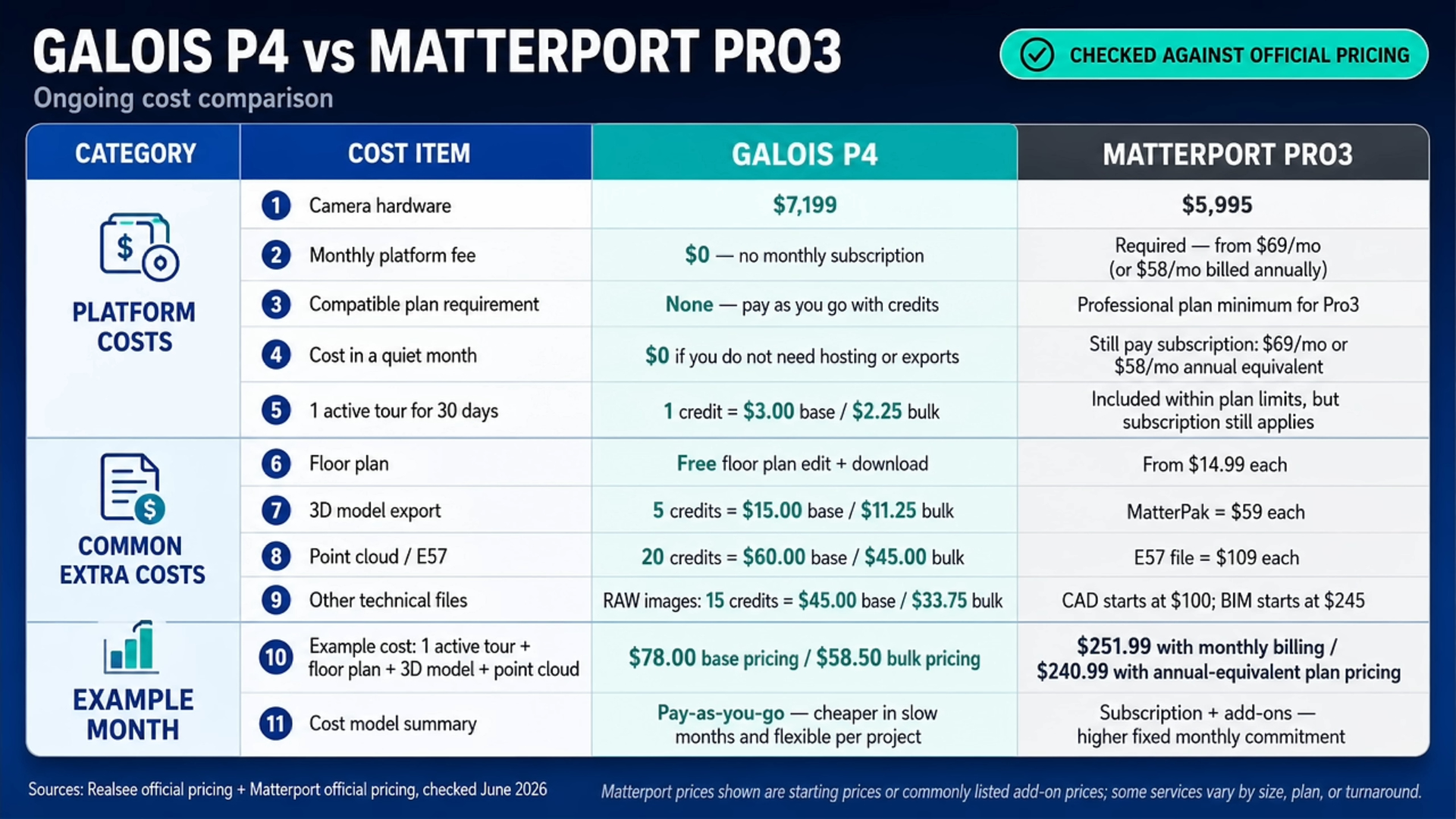
A Realsee virtual tour that remains hosted will continue to consume credits over time. However, the credit system may offer more flexibility because you only pay for certain deliverables when you actually need them.
For example, you may not need a point cloud or floor plan for every client. Under a credit-based model, you can avoid paying for outputs that are not required.
Is the Realsee P4 better than Matterport?
Based on its specifications and my experience using the Realsee system, the P4 is a serious Matterport alternative.
Its hardware is excellent, its image quality is outstanding and the workflow is easy to understand.
The Realsee P4 is more expensive upfront than the Matterport Pro3, but it may prove more flexible depending on how many spaces you host and which deliverables your clients request.
However, businesses should not make the decision based on camera specifications alone.
You should also compare:
- The hosting costs for your likely number of projects
- How long clients expect tours to remain online
- The price of floor plans and technical exports
- Compatibility with your clients’ existing systems
- The availability of support in your region
- The resale value of the hardware
- The maturity and recognition of each platform
Matterport has stronger brand recognition. Realsee, however, may offer better hardware and greater flexibility for some professional workflows.
Realsee P4 price and ongoing costs
The Realsee Galois P4 costs more than $7,000, depending on the package, distributor and region.
That makes it a major business investment rather than an impulse purchase.
In addition to buying the camera, users need to account for Realsee credits. Credits may be used for hosting tours and ordering additional deliverables.
The exact cost of operating the P4 will therefore depend on:
- The number of projects you complete
- How large each project is
- How long tours remain hosted
- Whether clients require floor plans
- Whether you need point clouds
- Whether you need downloadable panoramic images
- Which other technical outputs you provide
For commercial operators, these costs can be included within the project fee.
Rather than charging only for the scanning session, you could build your pricing around:
- Capture and scanning
- Processing
- A set hosting period
- Floor-plan creation
- Additional exports
- Extended hosting
- Travel
- Future updates or rescans
The important thing is to understand the credit cost before giving the client a final quote.
Realsee P4 advantages and disadvantages
| Advantages | Disadvantages |
|---|---|
| Exceptional panoramic image quality | Very high upfront price |
| Approximately 300-megapixel images | Ongoing credit and hosting costs |
| Excellent HDR performance | Too advanced for simple virtual tours |
| Micro Four Thirds image sensor | Large compared with compact 360 cameras |
| Fast individual scan times | Some exports cost extra |
| Long-range LiDAR scanning | Occasional chromatic aberration |
| 3D dollhouse and point-cloud creation | Careful scan positioning is still required |
| Automatic floor plans and measurements | Less brand recognition than Matterport |
| Large internal storage and touchscreen | Total operating cost varies by project |
Is the Realsee P4 worth buying?
The Realsee Galois P4 is worth considering when image quality, spatial accuracy and professional deliverables are central to your business. It is particularly compelling for companies that want a Matterport alternative but do not want to be entirely dependent on Matterport’s subscription model, nor their restrictive image usage policies.
The hardware is impressive. During my testing, it worked reliably, captured scans quickly and consistently produced excellent panoramic images. The combination of a Micro Four Thirds sensor and LiDAR scanner allows it to deliver both premium visual results and useful technical data.
There is no avoiding the cost. You need a clear business case before spending more than $7,000 on any camera. However, a business charging for high-end virtual tours, digital twins, floor plans and point-cloud exports may be able to recover the cost across multiple projects.
The P4 becomes more difficult to justify when you only need basic property tours or standard 360 photography.
Realsee P4 review: final thoughts
The Realsee Galois P4 is the best all-in-one virtual tour camera I have personally used.
It combines DSLR-like panoramic quality with fast LiDAR scanning and an impressively simple workflow. The camera handles exposure automatically, produces detailed 3D models and gives professional users access to a wide range of potential outputs.
This is a professional capture system designed for businesses that need accurate, highly detailed digital versions of physical spaces.
For those users, the Realsee P4 is not simply a credible Matterport alternative. In several areas, particularly panoramic image resolution and hardware specifications, it may be the more impressive system.
The decision ultimately comes down to whether your projects can justify the upfront investment and ongoing credit costs. For high-end virtual-tour businesses, architects, construction companies and other professionals who regularly capture complex spaces, the Realsee P4 deserves serious consideration.
Realsee P4 Discount Code
If at this point you find yourself interested in the Realsee P4 then I advise you to use the below link where you can get $300 off the price of the camera.
Realsee P4 frequently asked questions
How much does the Realsee P4 cost?
The Realsee Galois P4 costs more than $7,000, although the exact price may vary depending on your country, distributor and package.
Additional credits may be needed for hosting and certain exports or deliverables.
Does the Realsee P4 use LiDAR?
Yes. The Realsee P4 includes a 905nm LiDAR scanner capable of capturing up to 125,000 points per second.
The LiDAR data is used to understand the dimensions and geometry of the scanned environment.
What resolution does the Realsee P4 capture?
The P4 can produce virtual tours at up to 24K resolution, with panoramic images of approximately 300 megapixels.
Can the Realsee P4 create floor plans?
Yes. The P4’s LiDAR and 3D data can be used to generate floor plans automatically. This may require credits or an additional fee.
Can you download Realsee P4 panoramic images?
Yes. Individual panoramic images can be exported for use outside the Realsee platform, although downloading certain assets may involve an additional charge.
Is the Realsee P4 better than Matterport?
The P4 offers excellent hardware, extremely high-resolution panoramas, LiDAR scanning and large internal storage.
Whether it is better than Matterport will depend on your required workflow, hosting needs, preferred pricing structure and client expectations.
How long does a Realsee P4 scan take?
An individual scan takes approximately 16 seconds, although this may vary depending on the selected quality mode and capture conditions.
The total time needed to scan a property depends on the number of scan positions and the size and complexity of the building.
Is the Realsee P4 easy to use?
Yes. The camera automatically handles exposure, HDR and image stitching.
The operator mainly needs to position the camera correctly, trigger each scan and ensure sufficient overlap between scan points.
Can the Realsee P4 be used without a phone?
Yes. The built-in touchscreen allows scans to be triggered directly from the camera.
However, connecting to the mobile app is useful because it lets you monitor the model as it develops.
Is the Realsee P4 suitable for real estate?
Yes, particularly for luxury real estate, commercial properties and large developments where image quality, measurements, floor plans and 3D dollhouse models are valuable.
For basic residential listings, a less expensive 360 camera may provide better value.
Disclosure: Realsee supplied the P4 for testing and sponsored the original video. The camera was provided temporarily and had to be returned. All opinions and testing observations are my own.


Owner of threesixtycameras.com. Writer, photographer and videographer. You can see my YouTube channel for guides of how to shoot 360 video. I've written for The Times, Digital Photography School and Sunday Express.